
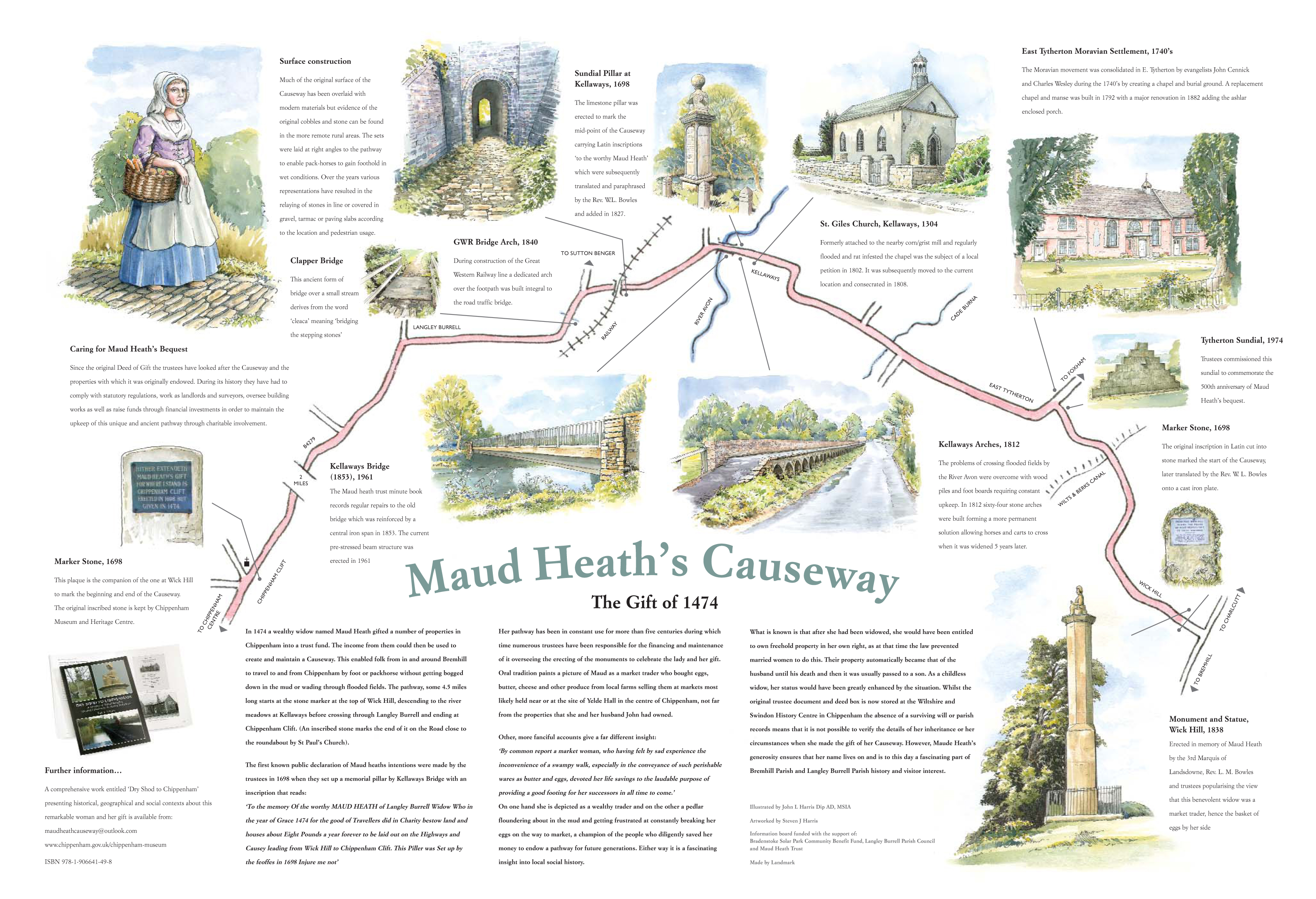
Maud Heath’s Causeway
Illustrated by John Harris
In 1474 a wealthy widow named Maud Heath gifted a number of properties in Chippenham into a trust fund so that the income from them could be used to create and maintain a causeway. This was to enable folk from in and around Bremhill to travel to and from Chippenham by foot or packhorse without getting bogged down in the mud or wading through flooded fields. The pathway, some 4.5 miles long starts at the stone marker at the top of Wick Hill, descending to the river meadows at Kellaways before crossing through Langley Burrell and ending at Chippenham Clift. (An inscribed stone marks the end of it on the Road close to the roundabout by St Paul’s Church).
The first known public declaration of Maud Heath’s intentions were made by the trustees in 1698 when they set up a memorial pillar by Kellaways Bridge with an inscription that reads:
‘To the memory Of the worthy MAUD HEATH of Langley Burrell Widow Who in the year of Grace 1474 for the good of Travellers did in Charity bestow land and houses about Eight Pounds a year forever to be laid out on the Highways and Causey leading from Wick Hill to Chippenham Clift. This Piller was Set up by the feoffes in 1698 Injure me not’
Her pathway has been in constant use for more than five centuries during which time numerous trustees have been responsible for the financing and maintenance of it overseeing the erecting of the monuments to celebrate the lady and her gift. Oral tradition paints a picture of Maud as a market trader who bought eggs, butter, cheese and other produce from local farms selling them at markets most likely held near or at the, site of Yelde Hall in the centre of Chippenham, not far from the properties that she and her husband John had owned.
Other, more fanciful accounts give a far different insight- “By common report a market woman, who having felt by sad experience the inconvenience of a swampy walk, especially in the conveyance of such perishable wares as butter and eggs, devoted her life savings to the laudable purpose of providing a good footing for her successors in all time to come.”
On one hand she is depicted as a wealthy trader and on the other a pedlar floundering about in the mud and getting frustrated at constantly breaking her eggs on the way to market, a champion of the people who diligently saved her money to endow a pathway for future generations. Either way it is a fascinating insight into local social history. What is known is that after she had been widowed, she would have been entitled to own freehold property in her own right, as at that time the law prevented married women to do this. Their property automatically became that of the husband until his death and then it was usually passed to a son. As a childless widow, her status would have been greatly enhanced by the situation. Whilst the original trustee document and deed box is now stored at the Wiltshire and Swindon History Centre in Chippenham the absence of a surviving will or parish records means that it is not possible to verify the details of her inheritance or her circumstances when she made the gift of her causeway. However, Maud Heath’s generosity ensures that her name lives on and is to this day an important and fascinating part of Bremhill Parish history and visitor interest.
The Trustees were entrusted to use the income from the properties and land to provide and maintain a causeway running from the top of Wick Hill into Chippenham Clift. It is reputed to be one of the oldest running Trusts in the world and is also one of the longest privately owned paths maintained by any Trust in the country.
The Causeway runs for 4½ miles through the parish of Bremhill from the top of Wick Hill down through East Tytherton, across Kellaways bridge and the River Avon, under the railway line through Langley Burrell and into Chippenham. Along the Causeway there are a number of monuments and historical sites within the parish of Bremhill which are all noteworthy.
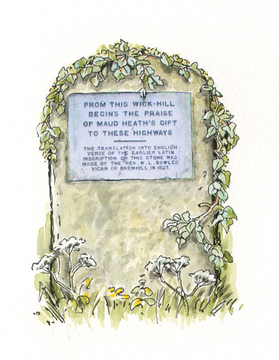
Wick Hill Marker Stone
Wick Hill Marker Stone. At the top of Wick Hill there is a simple stone pillar which is opposite Monument Farm. It was originally put in place in 1698 and it has a companion marker stone at Chippenham Clift at the other end of the Causeway. Its original inscription is lost but, in rhyme, it informed the traveller that this was indeed the starting point of the Causeway. A subsequent cast iron plaque affixed to the pillar denotes the start of the Causeway and attributes the translation of the Latin verse into English to the Reverend Bowles, Vicar of Bremhill in 1827.
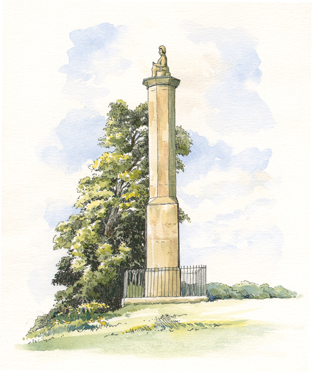
Maud Heath’s Monument and Statue, Wick Hill, 1838
Maud Heath’s Monument and Statue, Wick Hill, 1838. The imposing monument with a statue of Maud Heath was erected by the Third Marquis of Lansdowne and the Reverend Bowles to commemorate the life of Maud Heath. The myth had grown up by this stage that Maud Heath, rather than a wealthy widow, was in fact a local market woman. She is depicted in the statue as wearing a plain plebeian bonnet and simple clothes befitting a market trader. She also has with her a basket of eggs. The monument continues to undergo a programme of work and restoration. The monument is inscribed with:-
“Thou, who dos’t pause on this aerial height, Where Maud Heath’s pathway winds in shade or light, Christian wayfarer in a world of strife Be still, and ponder on the path of life”.
In January of 1990 severe storms beheaded poor old Maud Heath and her head fell from the monument rolling down the hill into a bramble patch. Fortunately, her head was recovered and returned to its rightful place during repairs and restorations undertaken in 1990 and 1991.
Tytherton Sundial 1974
Tytherton Sundial 1974. After crossing the old Wilts and Berks Canal, the Causeway arrives in East Tytherton. To commemorate the 500th anniversary of Maud Heath’s bequest a modern sundial was erected on East Tytherton’s green. Later on, in 1979, the Old Girls’ Society of Tytherton School (former pupils of the Moravian Girls’ School) dedicated a bench and this remains in front of the sundial.
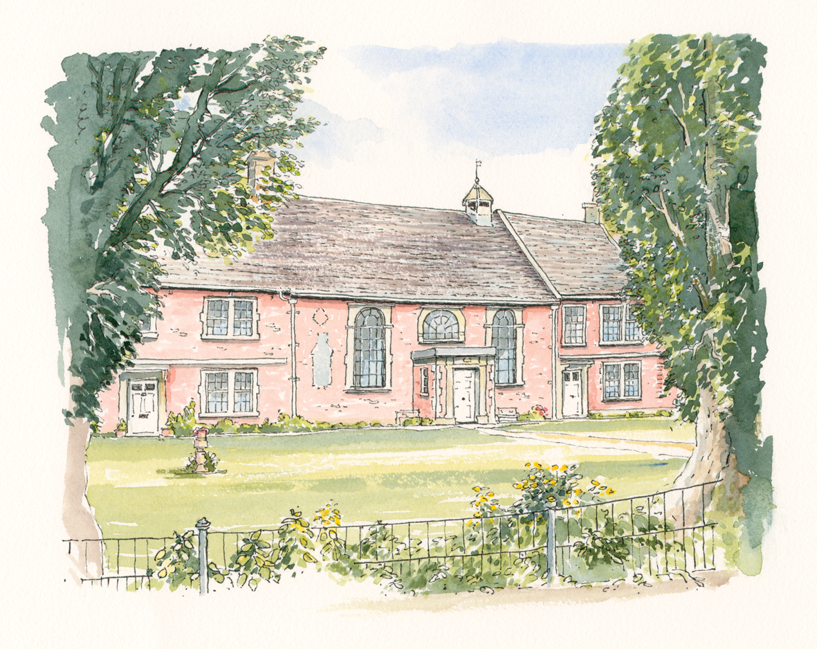
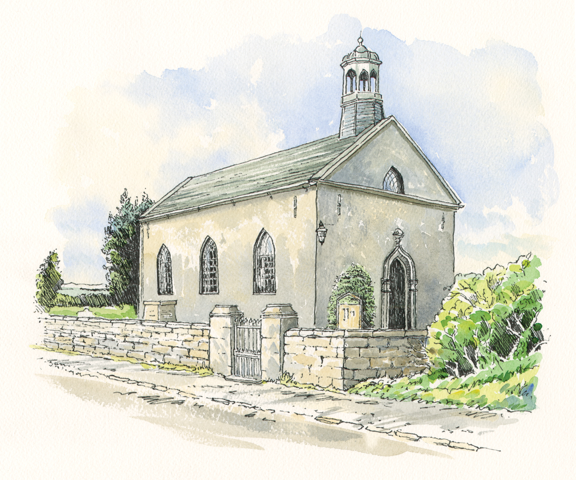
The Moravian Church East Tytherton
The Moravian Church East Tytherton. The Causeway continues in East Tytherton past the Moravian Church. The Moravian Church was a revival of a 15th century european religious sect attributed to the bohemian brethren. The red brick building, the centre of which remains the Moravian Church, is dated 1792.
The Quaker’s Burial Ground. As the Causeway continues through East Tytherton it passes Pinnegar’s House. Within the grounds of Pinnegar’s House tucked behind an ancient yew tree, the Quaker’s “friends’ burial ground” lies. Here it reports that some 110 Quakers are buried.
Barnbridge. After leaving East Tytherton the Causeway continues towards Kellaways. At Barnbridge the Causeway crosses over the Cade Burna. The word burna is an ancient Saxon word for stream. The Cade Burna drains a huge amount of rain water running down from the hills away from the plain and it continues to be a drainage system for the local area.
St Giles Church
St Giles Church. St Giles Church is one of the oldest churches on the Causeway. It was originally erected close to the River Avon in the early 14 th century. Plagued by the frequent flooding from the Avon and with the rats which used to infest the area, the church was eventually taken down and reportedly moved stone by stone to its new location on slightly higher ground just before the start of the iconic Kellaways arches.

Kellaways Arches
Kellaways Arches. Early problems of crossing flooded fields by the River Avon were overcome with wood piles and foot boards requiring constant upkeep. The current Kellaways arches were constructed in 1812. They consist of 64 spans raising the footpath well above the floodplain of the Avon. The stone arches were built forming a more permanent solution allowing horses and carts to cross when it was widened 5 years later. The Kellaways arches are in two sections separated by Kellaways Bridge as it crosses the main section of the River Avon.

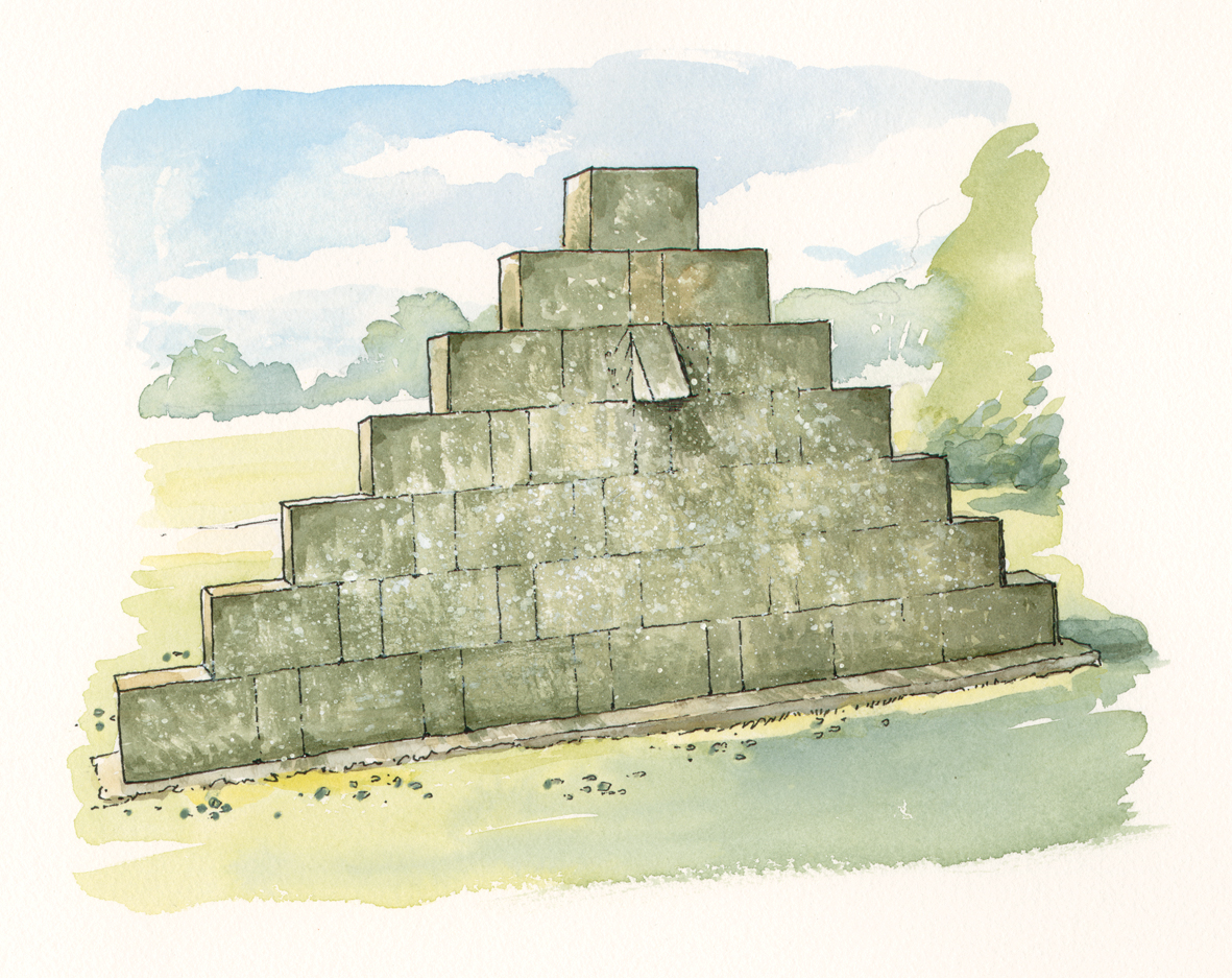
Sundial Pillar at Kellaways, 1698
Sundial Pillar at Kellaways, 1698. The limestone pillar was erected to mark the mid-point of the Causeway carrying Latin inscriptions to the worthy Maud heath which were subsequently translated and paraphrased by the Rev. W.L. Bowles and added in 1827. It includes a sundial which had Latin inscriptions on each face. These included (translated) ‘time flies’, ‘let us do good while there is time’ ‘and I will return you never’

Kellaways Bridge. 1853, 1961
Kellaways Bridge. (1853), 1961. The current Kellaways bridge was erected in 1961 due to the increasing traffic running through the road. The original cast iron Kellaways bridge was deemed inadequate for increasing modern traffic.

GWR Railway Bridge
GWR Railway Bridge. The Great Western Railway line connecting London to Bristol and running past Chippenham needed to cross over the Causeway. GWR set about purchasing land to span the road and the Causeway and initially proposed a single arch over the road and Causeway. Such was the influence of the Trustees at this time, they would only allow GWR to construct a bridge which had a separate arch forming a tunnel 15 metres long to enable the Causeway to run under the bridge unhindered.
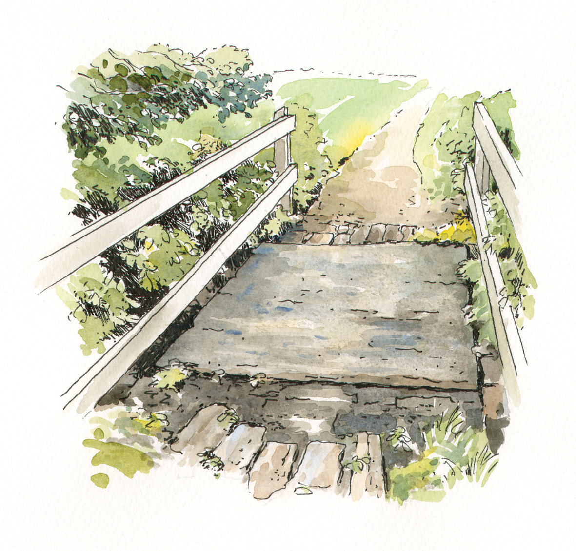
The Clapper Bridge
The Clapper Bridge. This ancient form of bridge over a small stream derives from the word ‘cleaca’ meaning ‘bridging the stepping stones’

End Marker Stone 1698
End Marker Stone 1698. The Causeway continues through Langley Burrell and hence into Chippenham where it finishes adjacent to St Paul’s Church. The end of the Causeway is marked by a further stone, again erected in 1698.
This plaque is the companion of the one at Wick Hill to mark the beginning and end of the Causeway. The original inscribed stone is kept by Chippenham Museum and Heritage Centre.
Surface construction
Much of the original surface of the Causeway has been overlaid with modern materials but evidence of the original cobbles and stone can be found in the more remote rural areas. The sets were laid at right angles to the pathway to enable pack-horses to gain foothold in wet conditions. Over the years various representations have resulted in the relaying of stones in line or covered in gravel, tarmac or paving slabs according to the location and pedestrian usage.
Caring for Maud Heath’s Bequest
Since the original Deed of Gift the trustees have looked after the Causeway and the properties with which it was originally endowed. During its history they have had to comply with statutory regulations, work as landlords and surveyors, oversee building works as well as raise funds through financial investments in order to maintain the upkeep of this unique and ancient pathway through charitable involvement
Further information…
A comprehensive work entitled ‘Dry Shod to Chippenham’ presenting historical, geographical and social contexts about this remarkable woman and her gift is available from - http://www.chippenham.gov.uk/chippenham-museum ISBN 978-1-906641-49-8
Maud Heath's Causeway Map
The above article, illustrations and map can be downloaded here.

Maud Heath's Causeway Map